|
|
Post by aharon on Sept 17, 2023 11:41:52 GMT -5
Shalom and greetings all my pals,
Important question please
Where can I find free old NZMC Mount Cook airport charts please for arrival and departure using airline propeller and jet planes, please? The internet shows only current NZMC charts only for use of helicopters. I would need old NZMC airport charts for DC-3s/C-47s and HS748 planes please.
Thanks for any assistance any of you might provide.
Regards,
Aharon
|
|
|
|
Post by phlyer on Sept 17, 2023 15:43:29 GMT -5
Looks like a VFR only airport nowadays.
Being surrounded by high terrain in all quadrants, it may never have had an instrument approach in the past and certainly probably no night ops. Airport elevation is 2100' and runway length is 5100' so it could certainly have handled classic props and some jets too.
The nearest VOR is some 22nm distant so not very useful as an approach aid.
Wikipedia shows various airline companies that used the airport in the past. It would be interesting to see how they handled getting in to the field in bad weather.
Phil
|
|
|
|
Post by aharon on Sept 17, 2023 15:49:17 GMT -5
|
|
|
|
Post by aharon on Sept 17, 2023 20:11:40 GMT -5
Looks like a VFR only airport nowadays. Being surrounded by high terrain in all quadrants, it may never have had an instrument approach in the past There used to be IFR AIP charts for NZMC for when Mount Cook took the ATR's there in Summer 2012/2013. They were still in circulation in the manuals up until at least 2020. That is what I have to look for and find on internet!
Regards,
Aharon
|
|
|
|
Post by Tom/CalClassic on Sept 17, 2023 22:00:40 GMT -5
Typically if there were no precision approaches the flights there were cancelled when the weather was below minimums. Sometimes they could fly into nearby airports and the passengers bused to the town. But often you just had to wait a day (or longer). I remember the Azores closed for close to a week due to bad weather in one article.
|
|
|
|
Post by phlyer on Sept 18, 2023 8:06:28 GMT -5
That ADF approach looks scary! Very unusual. The only NDB there today seems to be co-located with the VOR.
It looks like the approach is just meant to get you down to an altitude where you can proceed visually to the field. Wouldn't want to try it at night!
I just might have to use AFCAD to install the 2 NDB's shown and give it a try in flight sim.
Phil
|
|
|
|
Post by aharon on Sept 18, 2023 10:46:01 GMT -5
You might find the VATNZ pages easier to access the info? www.vatnz.net/airspace/airport/NZMCThanks mmmmm It looks like to me that waypoint MAMUS is the last waypoint before starting final runway approach on way to NZMC airport using visual route above the river called Tasman River Meanwhile I am still looking for IFR AIP charts for NZMC for when Mount Cook took the ATR's there in Summer 2012/2013. They were still in circulation in the manuals up until at least 2020. That is what I have to look for and find on internet! Regards, Aharon |
|
|
|
Post by mrcapitalism on Sept 20, 2023 0:16:35 GMT -5
Meanwhile I found old NZMC airport charts but they do not help me. Why do these not help you? They appear to be the official charts from the correct time period... I think they are fantastic. How did you find these? I initially did not find evidence of the operation of HS748 into NZMC, but I have since found this is true. Where do you find evidence of ATR's into NZMC? I would like to add my thoughts; This seems to be a nearly identical situation to the tutorial KIZG and 3B1 (Land at 'Greenville Seaplane Base'). Looking at my modern flight planning software, NZMC airport has no SIAP (Standard Instrument Approach Procedure), thus is VFR only. I doubted the existence of NZMC SIAP, but you can clearly see on satellite images the Non-Precision Approach runway markings are still painted on. In the modern world, we have NZGT Glentanner which has SIAP and is thus IFR capable. NZGT to NZMC is 8nm, an easy visual transit after instrument approach. 5sm is required to descend below the approach MDA. This would be a trivially easy 'backdate' to allow easy operation. Aharon has since found the vintage approach charts. I don't know why these are not good enough. Lets compare the vintage NZMC-2xADF(1966) and NZGT-RNP-A(2017) in 1966 there are 2 NDB's RS and CO which define a holding pattern about 3nm east of Mount Mary. In 2017 the holding pattern is directly on Mount Mary at intersection MAMUS. In addition, there is a DME radio transmitter RY in the exact same location. I bet if you look in your simulator, it will still be a VOR. Another tool for backdating. In 1966 (and 1970), the maximum airspeed for the 2xADF is 134 KIAS. In 2017, the maximum airspeed for the RNP-A is 120 KIAS. So you could go faster on the old approach. I don't believe the HS748 or ATR72 are Category B aircraft. I'm about 99% sure the ATR72 isn't, thus prohibited from this approach. In 1966, the lowest MDA in the holding pattern is 4,800ft MSL. In 2017, the MDA is 3,290ft MSL, while flying up the Lake Pukaki towards NZGT. Much lower. And you don't still have to fly around Mount Mary to reach NZMC. I think the new procedure is mostly superior to the old one, but there are plenty of opportunities for backdating the modern procedure. You could also hold over RY VOR, then fly outbound Radial 236, descending to 5,500ft. Upon reaching 4.4 DME, and rejecting the use of GPS, you could climb in right turn north for the missed approach. Lots of interesting options for this flight. |
|
|
|
Post by aharon on Sept 21, 2023 11:46:36 GMT -5
hy do these not help you? They appear to be the official charts from the correct time period... I think they are fantastic. How did you find these? Because I like airport chart approaches that tell me altitudes of surrounding mountains or mountains in front of runways on runway approach to any airport and I like airport chart approaches that tell me what altitude my plane should be at each of waypoints during runway approach. BUT that is okay. I can survive without approach charts because I can fly above huge lake between mountains on way to NZMC airport. Somebody gave me the link to some local New Zealand university's library database. Where do you find evidence of ATR's into NZMC? Here are plenty of proofs as seen below: www.stuff.co.nz/travel/destinations/nz/8118095/Mt-Cook-flight-popularwww.flyertalk.com/forum/trip-reports/1420551-spectacular-trip-aoraki-mount-cook-new-zealand.html (you need to scroll down to the post dated Dec 30, 2012, 2:04 pm made by Brenrox) www.jetphotos.com/photo/7565860 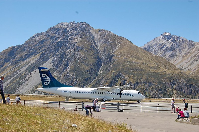  Thanks for explanations on speed limits for that NZMC airport. Regards, Aharon |
|
|
|
Post by aharon on Sept 21, 2023 14:16:53 GMT -5
Shalom and greetings all my pals, Pete Ham, who is real life New Zealand pilot and I think is member of CalClassic forums right here, is very very kind to take time from his busy schedule to look for his IRF charts from the past and found IRF charts for NZMC Mount Cook airport as seen below. Problem solved!! He said that doing an IFR approach to Mount Cook required a Glentanner/Mount Cook VOR/DME approach to MDA then proceed VFR 15.7nm to Mount Cook, or a Pukaki VOR/DME approach to MDA then proceed VFR 28nm to Mount Cook      Regards, Aharon |
|


