|
|
Post by brn1976 on Jun 29, 2014 7:58:42 GMT -5
|
|
|
|
Post by jacklyon on Jun 30, 2014 6:56:18 GMT -5
it's nice to see that a lot of people are interested in South and Central America airports for 1960.
I propose the following:
I will make a list of all importants airports, and i will indicate if we got period pictures and information
I someone already start working on one of these airports (as Caracas), we will put it on list
|
|
|
|
Post by jacklyon on Jun 30, 2014 7:01:42 GMT -5
OK, i start the list with airports
LIST OF AIRPORTS
--------------------------------------------------------------------------------
CARACAS // Venezuela
By Infiniti: (Work in progress )
--------------------------------------------------------------------------------
BUENOS AIRES // ARGENTINA [ Pictures: for the moment only a few, i need more)
By jacklyon (Work will start as soon i finish LFLY and LFBD)
--------------------------------------------------------------------------------
SAN JOSE // COSTA RICA (Pictures: a lot!!!)
By (?)
---------------------------------------------------------------------------------
|
|
|
|
Post by jwh on Jun 30, 2014 7:03:04 GMT -5
Will do all I can to assist with charts etc.
Also brn1976 how did you get the link to your Flickr page to appear in blue?
John
|
|
|
|
Post by jacklyon on Jun 30, 2014 7:03:57 GMT -5
Yes, i am interested also
John, if you can send me the link for the flickr as Saabi did?
Thanks
|
|
|
|
Post by jwh on Jun 30, 2014 7:06:48 GMT -5
I have 1961 charts for San Jose. Will scan tomorrow and upload them.
John
|
|
|
|
Post by jwh on Jun 30, 2014 7:44:08 GMT -5
Hi Jacklyon Below is the link that appears on the URL line of my Flickr page. Can't get it to appear in blue to give you a direct link to it, but hopefully this will help. www.flickr.com/photos/12530375@N08/In regard to San Jose. Is it planned to do the current El Coco Airport as it was in 1961 (now Juan Santamaria) or the original La Sabana Airport. Have a 1958 diagram for La Sabana. It didn't have a sealed runway, only 4000 feet of sod and gravel. Will do both tomorrow. John |
|
|
|
Post by jwh on Jun 30, 2014 7:45:31 GMT -5
Now the link is working. Can see why now.
|
|
|
|
Post by jacklyon on Jun 30, 2014 8:49:55 GMT -5
i see it
wow what collection!!!
i will check (and download after work)
|
|
|
|
Post by jacklyon on Jun 30, 2014 9:20:59 GMT -5
i see it
wow what collection!!!
i will check (and download after work)
|
|
Deleted
Deleted Member
Posts: 0
|
Post by Deleted on Jun 30, 2014 9:27:17 GMT -5
John, I always have problems do a search in your hugh photostream. If I search f.i. for your Key West chart - the first appearing in your stream - I get a lot of pictures about Key West, but by far not your chart. I never checked how Flickr is working in this matter.
|
|
|
|
Post by brn1976 on Jun 30, 2014 12:03:23 GMT -5
A while ago I played a bit with the old Galeao-terminal. I will check if I can find the source files and make them available. I also remember that Galeao in particular would require a bit of landclass work. Today's fs9 airport is built on a landfill that wasn't there yet in 1960ish. 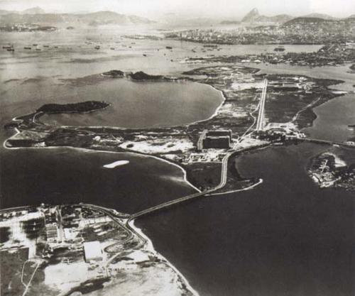 1473779118_c5264bd426 1473779118_c5264bd426 by brn1976, on Flickr |
|
|
|
Post by jwh on Jun 30, 2014 16:34:21 GMT -5
Hi Dan
The Key West charts are just after the Key West NAS photos.
Don't know how you do a search for any particular chart or photo now on Flickr. Their previous format was good until they changed it. The old saying "if it isn't broken, don't fix it" certainly applied here.
John
|
|
|
|
Post by jwh on Jul 1, 2014 1:29:50 GMT -5
Have uploaded following to my Flickr page JWHSHD:
La Sabana, San Jose, Costa Rica 1958 Airport diagram.
El Coco, San Jose, Costa Rica 1961 charts.
(El Coco is now Juan Santamaria International Airport)
John
|
|
|
|
Post by brn1976 on Jul 1, 2014 6:11:19 GMT -5
Looking forward doing this kind of approach with a Panair Connie:
|
|